Three parallel features have been found coming westward out of Chawton Park Wood. Making
maps in the usual way on OS 6":1Mile sheets produced distances between these features which
did not agree with measurements on the ground. OS map error had been suspected from
excavation of the central feature, resulting in us making maps from OS/RAF 1947-9 Air Photos
(Ref 1). The Southern Parallel Feature is a Roman Road, excavation shows it is made of crushed
flint between substantial packed flint revetments (Ref 2). The course of these has been traced
eastward in Ref 3, where it is interpreted that the Southern Feature is the first Road, taking little
heed of steep gradients, while the Northern is a later up-grade with gentle gradients.
The Central Feature is a 60 Roman foot-wide ditch with running lanes at its edges (Ref 4). The interpretation in Ref 3 is this is a water feature, collecting water falling on the Top Soil but trapped by the Clay natural, but also enabling things like logs to be hauled down the Clay bottom ditch to a saw mill at the bottom of the valley to the east. The direction of these Roads to the west is being determined. It is expected that one of them becomes a Centuriation Road of a large Roman estate which is being mapped to the west (Ref 5). See map of these.
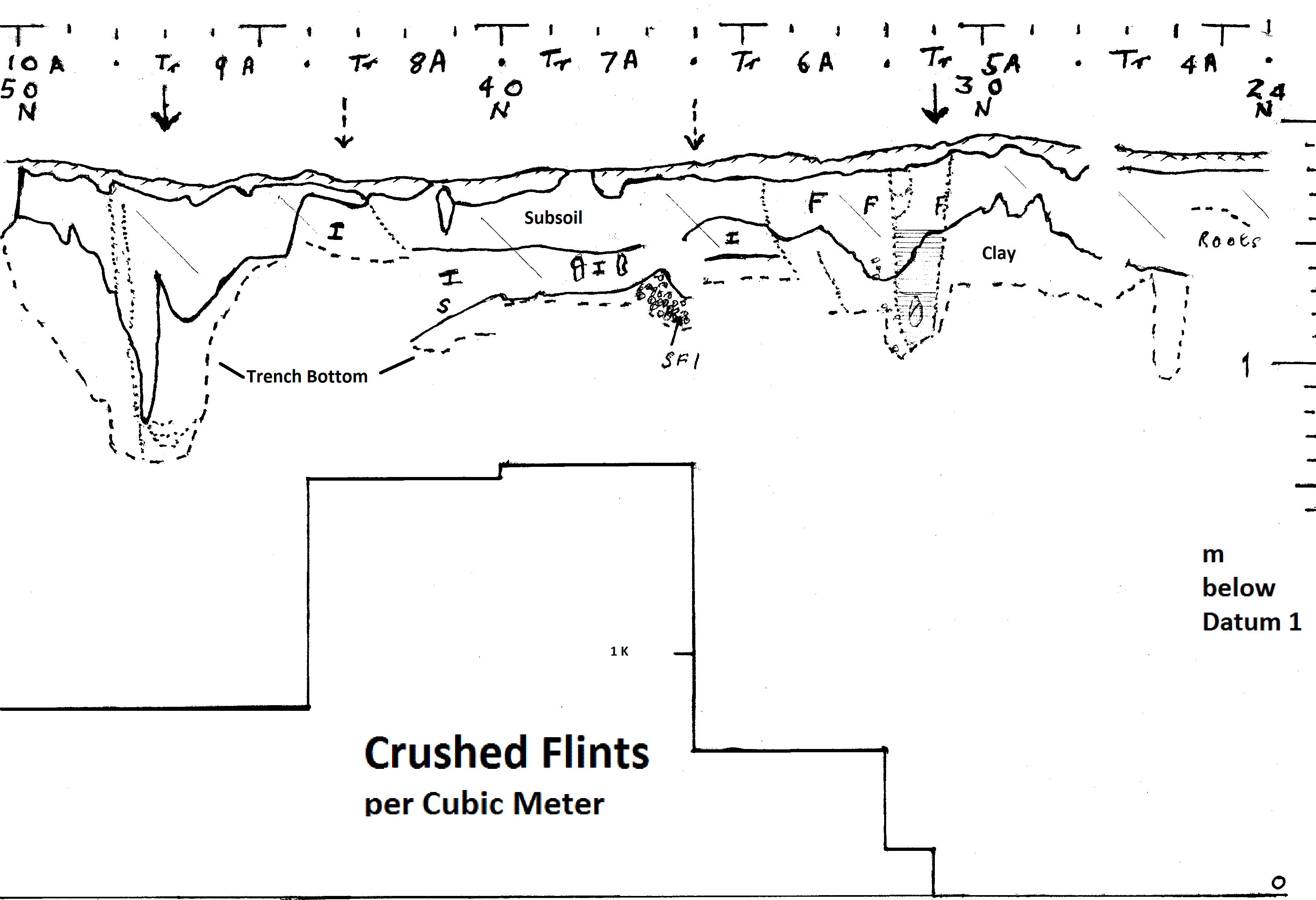
This report describes the excavation on this northern feature, on the edge of Chawton Park Wood, marked S on the map in Ref 1. The above Composite Section shows typical stratigraphy for this wood. Thin Top Soil, with 20-30cms of subsoil gradually getting redder into the clay natural. The estimated position of dark lines from air photographs are indicated by arrows, and a light line by dashed arrows between 36N-43N. The principal features found are two deep ditches corresponding with the dark lines, clearly showing on the Composite Section.
Starting the right (south) side of the Composite Section, the trench was taken down in Trench 4A to 1m depth. Unlike other excavations on the edge of Chawton Park Wood the clay natural did not pass the clay test of being able to role it into a sausage and bend it over with out it breaking. By 1m deep however we concluded it was the natural in this region.
South Ditch
In Trench 5A a substantial ditch over 1m deep was found. The Section photo shows several re-cuts (dotted lines) and an intricate pattern of silt lines between re-cuts at 31N (not drawn to scale). The re-cuts here are shown going into the trench bottom – so the full depth of the ditch was not reached. Some buried Top Soil is shown near this point. At 32N two small re-cuts can be seen, probably the final ones. Re-cuts also occur in Trench 6A at 34 & 35N, both going into the trench bottom. This suggests that the original ditch could have been over 4m wide – which is matched by evidence from the trowellers of Fill material (marked F on the Composite Section).
Crushed Flint
These Roads are likely to be Centuriation or estate Roads (Ref 5), and we have found that their metalling is crushed flint, probably laid thinly but frequently. This material does not show up in section, and is likely to be moved around by roots and frost action (Ref 6). We have developed ways of detecting it through counting the crushed flint found at intervals, and recording it with its depth. The occurrence of crushed flint is shown in the graph below the Composite Section. None was recorded until the Southern Ditch, then it rose steeply to well over 1,000 pieces per Cubic Meter at the start of the Light Air Photo Line, and fell abruptly at the edge of this Light Line in Trench 9A. The crushed flint occurs mainly in the subsoil, and confirms the cause of the Light Air Photo Line, and the construction of this Roman Road.
Some trowellers and section drawers recognised an Intermediate Layer between the Subsoil and the Clay, and the section photos indicate this occurs throughout the area under the light air photo line. This is shown as I on the Composite Section. The Roman practice of removing the soils and building their Road on the natural may be responsible – the upper subsoil would be younger than generally occurs.
A large accumulation of flint occurs on the southern edge of the Light Air Photo Line, but mainly in the clay. This contained a worked flint, shown as SF 1, indicating this accumulation is man-made. This may be a packed flint revetment seen in the excavation of the Southern Parallel Feature (Ref 2), where much of them were in the Clay, but a lot was also in the Subsoil. A pair mate was not found on the north edge of the Air Photo Light Line. A pit appears to have been cut here at some time. The Clay shelves down in Trench 8A from 40N, and a cut line appears on the section photo at 43N. A root system prevented Trench 8A being taken down to the depth where this packed flint occurs in Trench 7A.
North Ditch
Another large ditch was found under the Northern Air Photo Dark Line Arrow at 47N in Trench 9A, over a meter deep. Two re-cut lines are visible on the section photo at 48N, one of them going into the bottom of the trench, indicating we did not locate the ditch bottom. Some silt lines are visible at 45-47N, one going out of the Trench side at 46N. The profile of the Clay surface suggests this ditch was some 4m wide initially, the visible re-cuts were at a narrower width. These are unusually wide and deep Roman Road Side Ditches. In contrast, Margary's sections for major Roman Roads give ditch widths from 1m to 2.8m, and depths from 0.3m to 1.25m (Ref 7). As can be seen from this Report, and many others of our Roman Road Reports, detection of cut-lines and re-cuts from (colour) section photos considerably increases the width and depth of Roman Road side ditches from those seen and drawn on the excavations themselves. We do not know if these methods were available to the Ref 7 section drawings many of which will be well over 50 years old. Nevertheless the above Roman Road side ditches beat most of the Ref 7 dimensions by a considerable margin, for what is a minor Roman Road. It suggests they were cut for some purpose. In Medieval times such ditches along with hedges were used to keep livestock on the Road. Re-cuts seem to have reverted to more normal widths – but depths were maintained for many of them.
Crushed Flint Increases
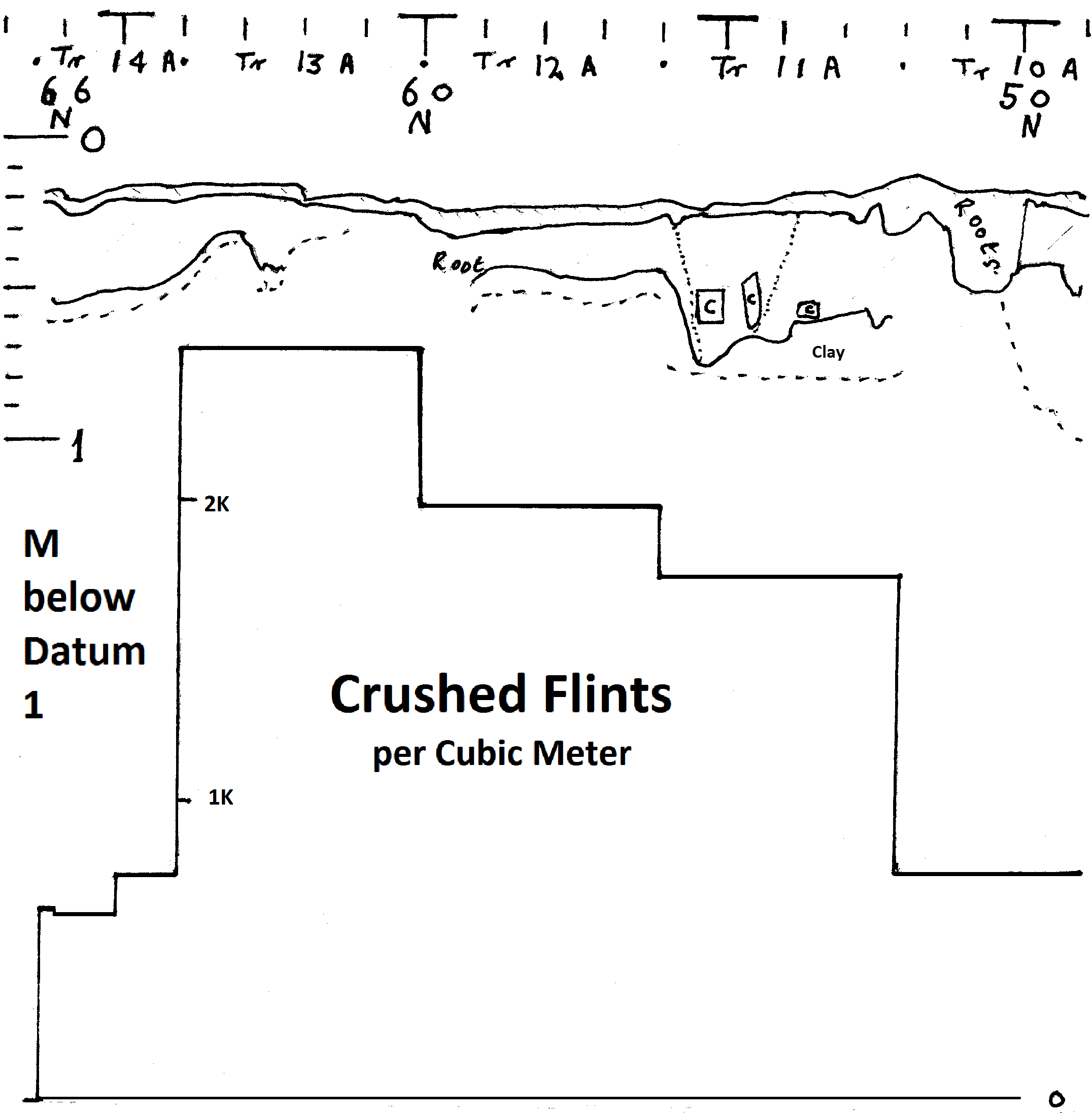
In continuing the excavation outside the expected Roman line, we found the Crushed Flint count rose again, so we continued the excavation until it fell. The continued Composite Section is given at the end of this Report.
The reason for the rise is Crushed Flint is apparent in Trench 11A, where three lines of Crushed Flint across the trench appeared. The northern line at 55N was clear on the section photo as a discrete area with parallel top and sides, marked C. The other two could be identified on the section photo but are less regular and distinct, and shown to the south also marked C to 53N. The north and south lanes would be able to take the wheels of Roman wagons, which were about 2m apart (Ref 8).
The Crushed Flint count continues to rise into Trench 13A to over 2K pieces per Cubic Meter – a lot higher than over the Roman Road. Then it falls in Trench 14A to similar levels as either side of the Roman Road. The individual meter counts shows this fall was a pretty abrupt fall. While the air photos show the light lines of the Roman Road in this region due to its considerably increased flint content, it is not possible to find a lighter area beside it – so this increased flint content in Trenches 11A-13A is likely to be localised. It may be that flints were collected from the surrounding woods and fields on Roman wagons and unloaded on the lines of crushed flint found in Trench 11A, crushed with iron hammers, and spread on the Roman Road as metalling – possibly with smaller specialist vehicles. This may have been at the Road's construction or subsequent re-surfacing. Then what we have found is the high concentration from a flint crushing region.
Interpretation
We have found a Roman Road with unusually big side ditches, between which was mainly crushed flint metalling. This is part of a three parallel feature system, probably being an upgrade of the first Road which is the southern parallel feature. Where these Roads go to the west is being investigated with the use of our Air Photo Maps. One of them is expected to be the Centuriation or Roman estate Road.
Acknowledgements
Thanks are due to Mr John Cray for permission to excavate on his land, and to the 153 man days contributed by the diggers. Richard Whaley
To print a full 1:20 Composite Section, Trenches 4A - 10A
Click here for full size Composite Section then
check your margins 9mm and set to Landscape - you may have to clear Headers & Footers.
[File - Print Set-up - Landscape, Margins 9mm, File - Print..].
After printing reset to default margins and Portrait.
REFERENCES
1. Chawton Park Wood Air Photo Map, NEHHAS FAB E News 4 Spring 2012
http://www.nehhas.org.uk/rd11-12.htm
2. Excavation of Southern Parallel feature in Chawton Park Wood, FAB e News 14 2016
http://www.nehhas.org.uk/rd12-15.htm
3. Southern parallel featue in Chawton Park Wood, NEHHAS FAB e News 10 Winter 2014 -15
http://www.nehhas.org.uk/rd13-14.htm
4. FAB e News 1 Autumn 2010 & 3 Spring 2012
http://www.nehhas.org.uk/rd06-9.htm,
http://www.nehhas.org.uk/rd10.htm
5. Note on Centuriation, NEHHAS Journal Vol 3, No 10 2015
6. Flints on the Roman Road, NEHHAS Journal 3, No. 11a, 2015
7. I Margary, Roman Roads in Britain, John Baker, London 1955 - 73 p500
8. Judith Weller, Roman Traction Systems, Der Humanist 1999,
http://www.humanist.de/rome/rts/index.html,
Wagon Construction
http://www.humanist.de/rome/rts/wagon.html
To print a full 1:20 Composite Section for Trenches 10A - 14A
Click here for full size Composite Section then
check your margins 9mm and set to Landscape - you may have to clear Headers & Footers.
[File - Print Set-up - Landscape, Margins 9mm, File - Print..].
After printing reset to default margins and Portrait.